Because my dad has an
adventurous, up-for-anything attitude, I took the opportunity of his recent visit as a chance to do something I've been dreaming of for awhile - kayak in Crockett Lake. This body of water, sitting consistently still yet amazingly close to the ocean had beckoned me with endless possibilities - hidden passages through the sedges, dozens of bird species, and who knows - maybe
the remains of a mammoth, buried for centuries in the mud.
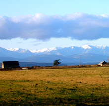
 Crockett Lake is situated on the western edge of the middle of Whidbey Island, separated from Puget Sound’s waters by the tenuously thin strip of land called Keystone Spit. Today Crockett Lake and Keystone Spit are home to numerous plant and wetland bird species overlooking the majestic Olympic Mountains southwest across the Admiralty Inlet, and the quiet field and forest patchwork that charmed explorers and pioneers from the mid 1700s on.
 Sometimes brackish, sometimes fresh, Crockett Lake has undergone many changes since the Crockett families staked their Donation Land Claims in the 1850s. When Walter and Samuel Crockett arrived, the lake was over 500 acres. By the 1940s and 50s the lake had been drained to little more than 10 acres, making way for more farmland. Through the years, the lake levels had fluctuated depending on the status of the tidegate installed between the Lake and the Sound.

Today the lake is a shallow brackish body of water with salt and freshwater marshes and wetlands with a large rocky beach berm separating the lake from Admiralty Bay on Keystone Spit. Migratory waterfowl can land on loafing islands in the lake when the lake is low and feed on these critical feeding grounds after making their journey from the North. This special wintering and nesting area is a perfect habitat for 13 species of ducks. Nature is plentiful here with wildlife and an ecosystem that can survive the elements of a harsh windy landscape along Whidbey’s West side.

Knowing our kayaks could travel through 5 inches of water, we entered through a long, narrow channel on the Southwest side of the lake - hoping it would open up into manageable waters. Unfortunately it never did.
Instead, we had to constantly maneuver our boats to the deepest possible route, frequently digging our paddles through almost-black mud with an impossible smell. We debated turning around, but I was determined to kayak around the mysterious remains of a road, running through the center of the lake.
Progress often flirted with Crockett Lake and the Keystone Spit during the last century and a half. Anticipation of the Great Northern Railway passing through Whidbey Island on its way to Port Townsend sent speculators into a frenzy platting the towns of “Chicago” and “Brooklyn” on the Keystone Spit to take advantage of the new commerce promised by the impending railroad in the late 1880s. Within two years, it became apparent the railroad would not arrive and the newly minted town plats were abandoned. Little remains of the two towns platted for Keystone Spit, but the pilings of an old bridge crossing Crockett Lake are still visible. Around 1890, boats would arrive from Port Townsend and people would disembark carrying picnic baskets to walk across the bridge on the lake to Crockett’s Orchard for a day outing with their family. The Crockett’s allowed folks to picnic in their orchard next to the lake. The pilings are all that remain of the bridge today that once was the inspiration of big development on “the spit” that never came to be.

Although I did get stuck in the layer of thick scum that covered the water - especially around the pilings - it was pretty neat to see the multitudes of Great Blue Herons that used these upright beams as a resting place.
In the 1970s, progress again turned its eye to Crockett Lake and Keystone Spit. American affluence and recreational desires led to the next development speculation. As other coastal Whidbey Island regions developed and land prices drove higher, plans were again drawn to develop Keystone Spit, including a marina on Crockett Lake and 182 home development titled ‘Seabreeze’. The new proposals induced the local community to band together against the proposed development and fight for preservation. As the developer began constructing roads, service lines and model homes on the spit, activist group Save Whidbey Island For Tomorrow (SWIFT), the Washington Environmental Council, the Seattle Audubon Society and Dr. Cecil Riggall of Coupeville filed suit to stop the development. In time, the Army Corps of Engineers halted the proposed marina and the lawsuit against development succeeded in permanently halting the Keystone Spit development, though after roads and service lines were in place.
The push to conserve the Keystone Spit and Crockett Lake area took many turns and lots of money during the 1970s and played a large part in the creation of Ebey’s Landing National Historical Reserve in 1978. The creation of the new Reserve didn’t preclude development on Keystone Spit entirely, but updated sewage disposal restrictions made development on the spit unlikely until technology could overcome the problem in the future. Crockett Lake and Keystone Spit conservations twists and turns continued well into the 1980s before all the pieces fell into place to conserve the area as it is today.

Crockett Lake and Keystone Spit’s brushes with ‘progress’ are barely noticeable to Whidbey Island visitors today as they arrive on the Coupeville/ Port Townsend ferry to visit the local fort, or watch birds through field glasses. Visitors on the shore will notice the pickleweed in the spring, near the lake’s edge, with strings of orange dodder wrapped around its small succulent branches, and the sweet smell of the wild rose in the summer. Thanks to luck and the foresight of Central Whidbey Island residents, visitors are still able to enjoy that majestic mountain view and park-like setting so enticing to the explorers and pioneers of the past.
When our boats, covered in mud, were safely strapped to the car at the end of our trip my dad remarked, "Well, I'm glad we came. I don't need to do that again, but it was pretty cool."
Special thanks to Reserve Rangers Lauren Gansemer and Sally Straathof for their great research on Crockett Lake!

 Upon arrival at the Jacob Ebey house, after coffee, fruit and scones, the guests gathered at the front steps and heard Ebey’s Reserve Operations Manager Craig Holmquist give details about the restoration work done on the Jacob Ebey house over the past four years. Craig told how the original windows were restored, how a new foundation was put down is a style similar to the original foundation, and how the chimneys were lifted with the rest of the house and re-pointed by the NPS restoration crew. He pointed out the new hand split cedar shake roof and talked about the changes on the interior of the building in preparation for the Jacob Ebey House debut as the Ebey’s Landing National Historical Reserve Visitor Contact Station in spring 2011.
 Reserve Manager Mark Preiss then welcomed the guests inside the house where the Long Range Interpretive Plan (LRIP) was presented. The plans are the work of many months and many people who care deeply about Ebey’s Reserve and are committed to sharing the messages central to the Reserve with visitors from around the world. With the LRIP distributed to the guests, Emi Gunn spent a bit of time reviewing the main interpretive themes, showcasing some of the Reserve’s recent achievements and talking about the next priorities on the horizon.